Langhans and Romps, The origin of water-vapor rings in tropical oceanic cold pools, GRL, 2015
Paper
Description
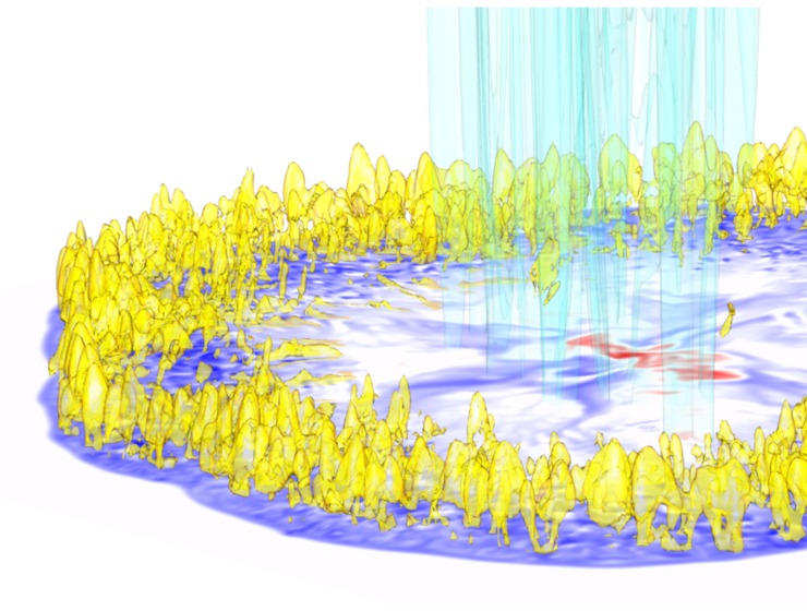
A snapshot of a cold pool from the large-eddy simulation showing (yellow) the water-vapor mass density perturbation, (turquois) the mass density of rain water, and (contoured: purple=cold and red=warm) the perturbation of the air temperature at 55 m. Data is shown up to a height of 2.5 km.

Over the tropical ocean, deeply convecting clouds typically start as air near the ocean surface, and their ascent is powered by water vapor, which serves as the clouds' fuel. Therefore, these clouds tend to originate from near-surface air that is more humid than average. Those regions of high water-vapor content are often found at the edges of cold pools, which are cold, dense pools of air that are generated by precipitation and that spread out like an expanding circle. Therefore, in the search for a theory of tropical deep convection, a key question is what process generates those rings of high water-vapor content at the edges of cold pools.
For over a decade, the prime suspect has been the precipitation itself. As precipitation begins to falls through boundary-layer air, it cools and moistens it. As the cold pool spreads, that humid air would be carried to the edge of the cold pool, forming the familiar water-vapor rings. But, as shown here, this is not the mechanism that generates these rings.
Using carefully chosen tracers of water vapor in a large-eddy simulation, we show here that water-vapor fluxes from the ocean surface are solely responsible for generating these water-vapor rings. Why does precipitation not generate, or at least contribute, to the formation of those water-vapor anomalies? The boundary-layer air that is initially underneath the precipitation is exposed to the precipitation for much too short a time: the condensate loading weighs down the air and pushes it out of the way of the precipitation before significant moistening is possible.